

In a previous project I looked at using a PostgreSQL database along with QGIS to collaborative working and live updates to webmaps.
I did not however touch on the data collection through mobile devices. With almost eveyone carrying phones around with them day by day they introduce a great opportunity for a simple and easy to use data collection method.
Esri has a well implemented system through their ArcGIS Field Maps. Using this the user is able to add layers for data collection such as points of interest, forms to fill in and even include geofencing to alert a user when they enter a specific zone.
This system works well and having experienced its use on both international and domestic projects it definitely is the future and the way to move forward with data collection.
It allows a type of collaborative workflow between field users and office based users to work on the data immediately and receieve remote support in the form of additional analysis.
However, there are times where this system may not be the best fit for people. I believe Esri Field Maps works brilliantly for those already using the system and for ease-of-use. Without much effort from the user they are able to combine and implement layers and take them further onto dashboards and webmaps without needing to worry about some other details.
I first became interested in the idea of finding another way to implement mobile data collection when work came through where an alternative was required for as low a cost as reasonably possible.
My first implementation of this idea was completely independent of both Esri and QGIS. This project focused on using a Flask server with a SQLite backend for storing point information. This was before I took the time to look into and learn PostgreSQL and PostGIS. So the webapp would use the device location for points and could only take a point_id and comment.
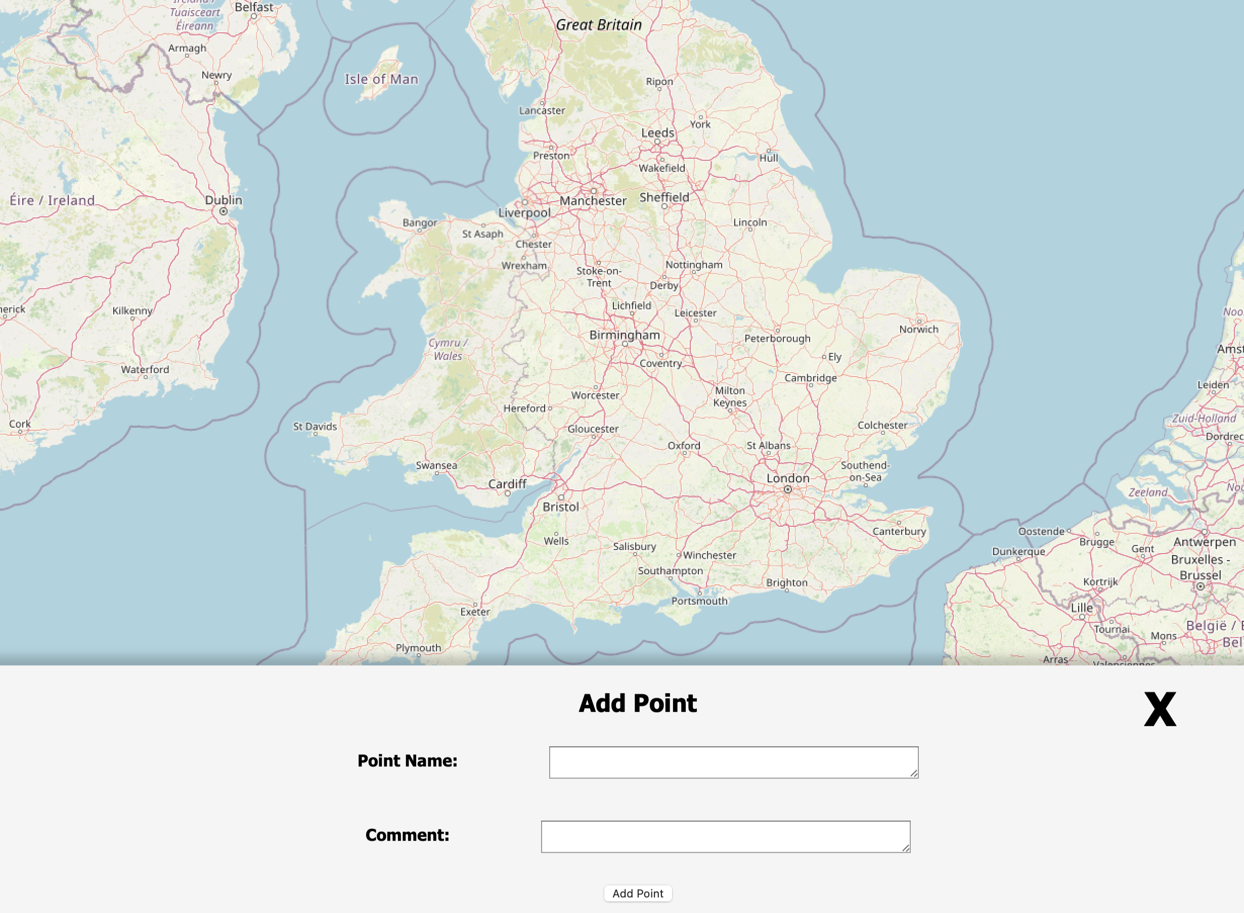
This was dependent on the user having a web connection and was too simplistic. The app was going to need to be capable of associating images with points, work offline and allow the user to make much more complex edits such as drawing areas and lines. Next to be tested was QField. This app works similar to Esri's Field Maps. The implementation is not as polished for user experience however.
QField is the free and open-source alternative which works alongside QGIS desktop. For this to work, the user it required to use the QFieldSync plugin for QGIS.
This plugin packages up a QGIS project into a file accessible by the app on mobile devices. This is the workflow I used when producing the PostGIS project. Observations were taken in the field using a loaded PostGIS connection layer for the points.
Most of the time the mobile projects are using geopackage layers. This allows for offline editing in an environment where a stable connection may be hard to keep. In this way, the user works on the device locally and at the end of the day they can copy the project back over to desktop where they can work through the updates.
This workflow may be sufficient for some people that don't mind spending the extra time moving files around, but it leads to the next solution.
With Esri's Field Maps the data is attempting to syncrhonize on intervals or with a manual push which will send the data up to your cloud-based AGOL interface. Here the data is directly ready for use with webmaps, dashboards etc. as previously stated.
This leads on to QFieldCloud. The QFieldSync plugin has built in support for QFieldCloud. On this service the user can sign up and manage their projects, however, there is a free-tier limit. With this tool the projects are no longer manually moved across between devices and instead a synchronize button is used to push and pull data between server and device.
The provided service by OPENGIS.ch works well, but due to the open-source nature of the project we are able to take this service and self-host it on our own systems.
The documentation for this is covered well on the Github Repository for QFieldCloud. Here is a quick rundown for windows systems:
Once you have checked the system is up and running it is ready for connection to on QField mobile as well as through QGIS.
The docker container will run the service at port :8011 of the device. From here you can log in with the created super user and fiddle with various settings, create users and projects etc.
This will be accessible from the IP address of the device running the container. For example 192.168.1.1:8011.
For this to be accessed from outside the local network port-forwarding will be required. In my use case I have a Raspberry Pi set up with wireguard on the same network. This allows me to connect via wireguard VPN and access my cloud server from anywhere.
For this example I started with a blank QGIS project and loaded in some lidar data from Defra. A google satellite WMS layer was included beneath this to act as a basemap. I changed the view of the lidar DEM to be 1m interval contours.
Now for the mobile collection part. I created a new geopackage layer named Collected_points. Within this we will set up an attribute form which will be filled in by the user as they use the app. I included the following fields:
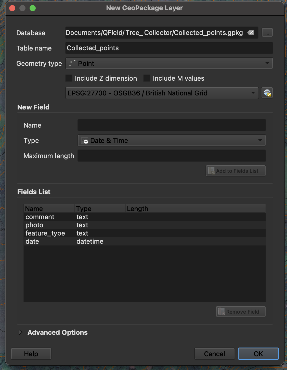
We will be using the FID generated automatically for each feature as its object id. The comment will be a text input by the user with no set limit. Photo is using text currently as it will be a path, this will be configured in the attribute form. Feature type is using a text input too, but this will be set up with a value map to allow easy to use dropdowns for the user. Date is using datetime and will be automatically populated upon record being made.
Once the layer is set up and saved, we can begin to edit the attribute form. First, I have chosen to hide the fid as it is autogenerated and not relevant to the user here. Then I move onto the photo field to make a few adjustments. The first is to set the Widget Type to Attachment. I then set the default path to a folder called 'Pictures' within the project directory using: file_path(@project_path) + '\Pictures\' making sure to leave Store path as to be 'Relative to project path'.
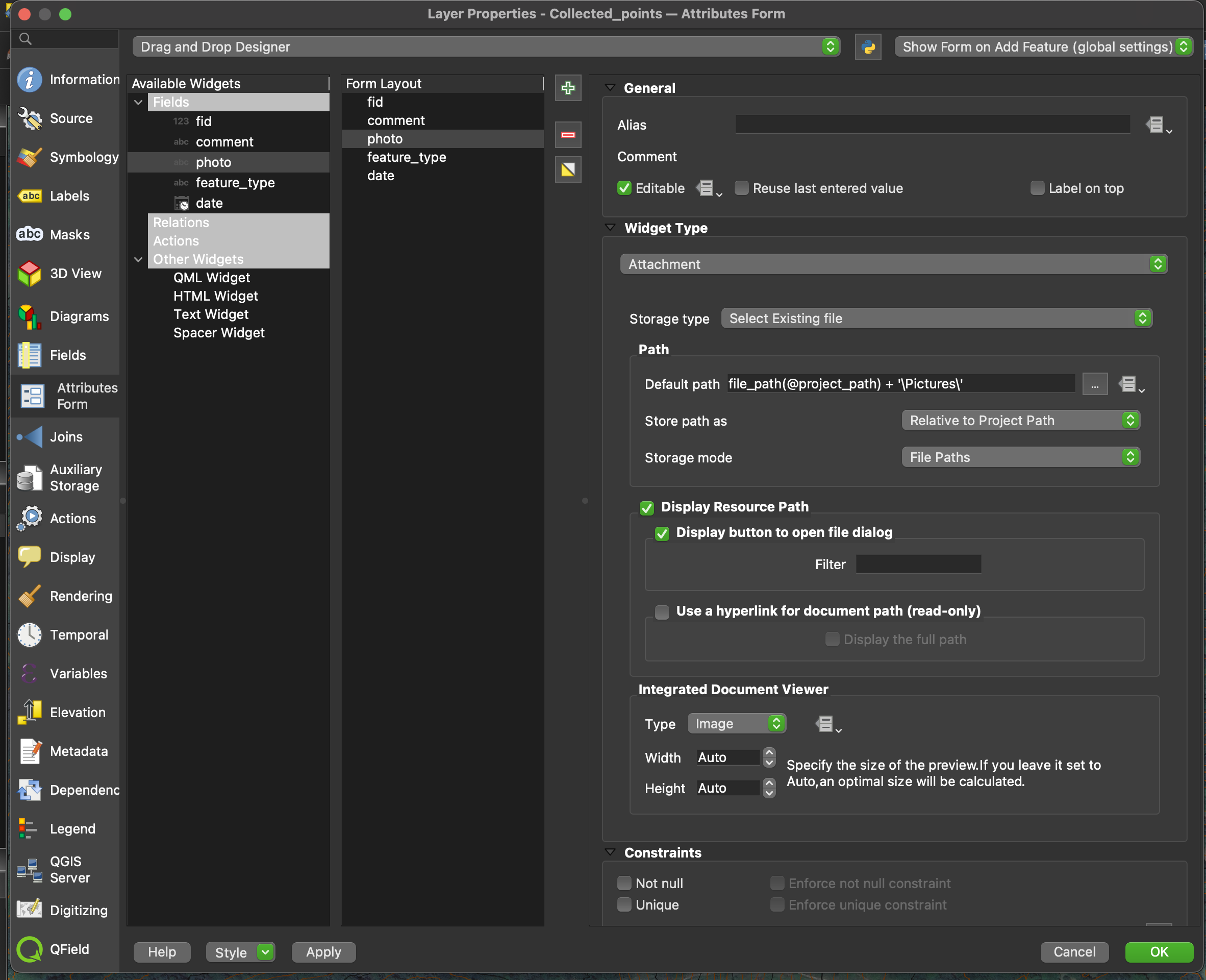
For feature_type I changed the Widget Type to be Value Map. Within here a few options were assigned values and descriptions. I have stuck with strings for the values as the dataset being collected is qualitative rather than quantitative with the results being undefined at the start. Below is an example of adding a point in QGIS desktop with the new attribute form in place.
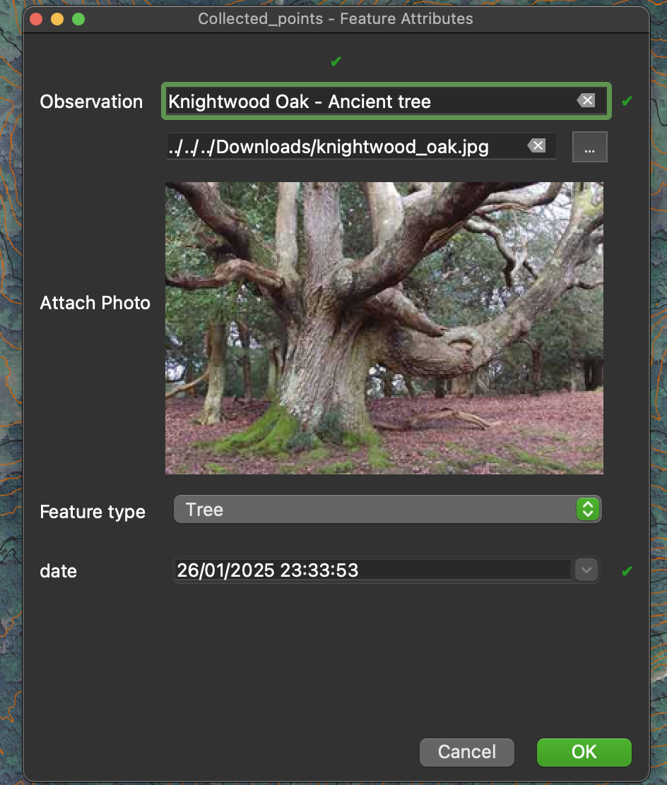
The project is now ready to be synchronized with QFieldCloud and the mobile device. For this, in the QFieldSync toolbar there is a button for synchronizing. Within this it will show the changes between the local file and the cloud file. In this case however, there are no projects on the cloud. So for this I chose to create a new project from current. A title for the project, a short description and then a local directory was set up. This is where we will be syncing from and to in the future. The files will be pushed to the cloud and are then ready for the mobile collector.
With all of the desktop work out of the way, it is time to connect the QField app to the server.
For this, within the app select QFieldCloud Projects and this will bring you to a login page.
Tap on the Bee icon three times to reveal the server it is connecting too. For the address, we will be using either the public ip (if portforwarding was carried out) or the local ip of the device running the docker containers.
For example you may input http://192.168.1.1:8011. Then follow this with the username and password for the user you will be logging in as.
The next page will show the projects which the current user is associated with or allowed access to. Select the project we have created and our QFieldCloud server will package it up for local use. This will download the files to the mobile device, allowing the project to be taken offline and into areas with unreliable network coverage.
Within the map view of the project we can turn layers on and off, adjust the transparency etc. as in the desktop version. In order to add points, the user will select the layer from the layers list, toggle editing at the top and then a button will be added in the bottom right for adding data to the project.
Using this will open up our attribute form which was created in QGIS desktop.
Other points can also be edited by tapping on them whilst in the edit mode.
After adding some points or making any changes, the project can then be synchronized back to the cloud so that the data can be looked at on desktop. For this there is a sychronize button in the sidebar menu.
Once back on desktop, hit the synchronize button from earlier and update the local files based on the cloud files. This will pull the changes the mobile device has made on the cloud to your local files.
Now, viewing the project will have the collected data which can be utilised for further tasks such as performing analysis/report generation.

The system currently works well for setting up simple projects in QGIS and the user being able to synchronize to a mobile device with a button rather than needing to move files around.
More advanced collector apps can use relations between layers, for example in auto-populating fields based on location.
I am interested in producing a cloud-based dashboard where layers can be viewed and used for tasks such as producing web maps dynamically. One option currently, as with my previous project, is to use the layers loaded directly from PostGIS.
As long as the user retains a steady internet connection they can add points and edit data on this layer using QField. This will update on the server live where it will reflect on maps, dashboards etc. Anything that uses the Postgres connection will also update live with the data.
The other option here is to set up auto-push of data in QField. However, a lot of the sites in my experience have unreliable connection. For this reason I also do not use the PostGIS approach.
In order to implement a system similar to a management dashboard I plan to create a system which catalogues created layers, assigning them a unique id. From this a plugin will be made for QGIS which will have an option to synchronize the geopackage data with the database.
This will act like the QField synchronize to cloud, but to push the data to a management location. I'm not a fan of double handling the data and intend to look into an implementation which can work directly through QFieldCloud, however, this will allow the user to have webmap views or dashboards where a layer is selected using an id and will display the data from the cloud.